Scientists update geological map of UP, northern Wisconsin
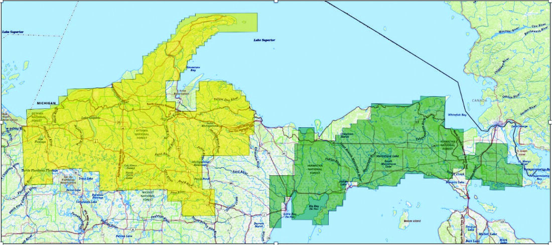
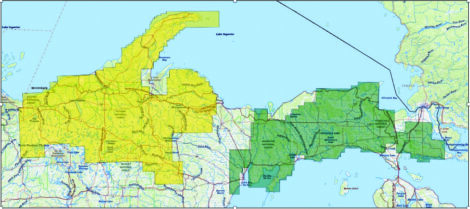
A Map of the Upper Peninsula of Michigan and nearby areas of Northern Wisconsin, with areas of overflights shaded in yellow and green. (Photo courtesy of the U.S. Geological Survey)
LANSING — In the summer, the U.S. Geological Survey began large-scale low-level airplane flights over the Upper Peninsula and northern Wisconsin.
The goal of the project is to obtain high-resolution data on subsurface mineral structures and bedrock composition to depths of approximately 10,000 feet.
The data will be used to create two- and three-dimensional maps, which will help to better understand the geological structure at those depths.
The geological surveys of the two states are working closely with the U.S. Geological Survey to interpret and create maps from the data.
“This project is part of a national initiative aimed at acquiring modern, high-resolution geophysical data. Unlike the outdated and limited-quality public data that exists for our region, this new data will have much higher resolution and will allow for more accurate information about the region’s geology,” said Ashley Quigley, a senior research associate from Western Michigan University who works with the Michigan Geological Survey.
According to the U.S. Geological Survey, aircraft used for the surveys are equipped with an elongated “stinger” mounted to the tail, extending backward off the aircraft.
The agency also says the instruments are passive, emit nothing harmful, pose no risk to humans, animals or plants, and that no photography or video data is collected.
“Two types of geophysical surveys are being conducted: a magnetic and radiometric survey and an electromagnetic survey, which are being collected for the first time across the entire region,” Quigley said.
“Previously, we only had access to low-resolution data covering part of the UP, while the new survey will provide detailed data for the entire region,” she said.
The survey covered counties on both sides of the state line, including Alger, Marquette and Schoolcraft in Michigan, as well as Vilas, Iron and Florence in Wisconsin.
Flights are conducted at an altitude of about 330 feet, and the flight lines are spaced approximately 500 feet apart in the western part of the region and 1,300 feet in the eastern part.
Radiometric sensors measure natural low-level radiation, helping to map the distribution of potassium, thorium and uranium at the surface.
“We hope the new data will help us to better understand the natural resources of our state, including critical minerals and aggregates. The data will also be useful for investigating Michigan’s water resources and land-use planning,” Quigley said.
“We are confident that it will help us understand the geological structure of the region much more accurately. For example, we will be able to confidently predict what the bedrock looks like in areas covered by glacial sand and soil,” said Bob Mahin, a critical minerals geologist from Western Michigan University who works with Quigley.
The project is funded and managed by the federal agency as part of the Earth Mapping Resources Initiative.
The aerial surveys are conducted by specialized contractors Woolpert and EON Geosciences.
“The main challenge we face is the vast amount of data that needs to be interpreted. Our team has only three geologists specializing in Precambrian geology, and given the complexity of the geology of the western UP we will face a long and labor-intensive process of analyzing this data,” Mahin said.
According to the federal agency, the data will be publicly available on ScienceBase and will support the development of three-dimensional geological models and maps to help assess natural hazards, identify mineral and water resources, and inform land-use planning.
Mahin said, “Local communities, businesses and government agencies will use the data in various areas, such as assessing water resources, characterizing aquifers near former mining areas and planning infrastructure and land use.”
“We are confident that this data will be useful for local communities and will contribute to improving the quality of life and safety,” Mahin said.
Front Page News

Do’s and don’ts of using AI to help with schoolwork
Evening of Thanks set for Tuesday night
MARQUETTE — The Marquette Interfaith Forum is hosting its annual Evening of Thanks at 6 p.m. on Tuesday at ...

Cheer Club now accepting donations
Scientists update geological map of UP, northern Wisconsin

Whitmer asks US Supreme Court to weigh state immunity in Line 5 case