Weather
Marquette and vicinity: Rain and snow likely before 1pm, then rain. High near 38. Southeast wind 10 to 15 mph. Chance of precipitation is 80%. New snow accumulation of less than one inch possible. Tonight. Rain. Low around 37. Southeast wind 10 to 15 mph, with gusts as high as 20 mph. Chance of precipitation is 80%. New precipitation amounts between a quarter and half of an inch possible. Tuesday, rain. High near 48. Breezy, with a southeast wind 15 to 20 mph, with gusts as high as 30 mph. Chance of precipitation is 100%. Tuesday night, rain showers likely before 11 p.m., then rain and snow showers likely between p.m. and a.m., then a chance of snow showers after 2 a.m.. Mostly cloudy, with a low around 24. Chance of precipitation is 60%
Extended forecast: Wednesday, a 30 percent chance of snow showers before 8 a.m. Mostly cloudy, with a high near 35. Wednesday night, mostly cloudy, with a low around 22.
Lake Superior: Monday, southeast wind 10 to 20 knots. Cloudy. A chance of snow possibly mixed with rain in the morning, then rain likely in the afternoon. Waves subsiding to 2 to 3 feet, then building to 2 to 4 feet. Monday night, southeast wind 10 to 20 knots with gusts up to 30 knots. A chance of rain in the evening, then rain after midnight. Waves building to 2 to 3 feet.
Temperatures: The average temperature Sunday at the National Weather Service office in Negaunee Township was 30.7 degrees, eight degrees above normal. The high Sunday was 34 degrees and the overnight low was 16 degrees.
Precipitation: Sunday, trace. Year to date, 4.78 inches. Normal to date, 6.02 inches.
Snowfall: Sunday, trace. Season to date, 97.3 inches. Normal to date, 172.6 inches.
Sunset: 7:43 this evening.
Sunrise: 8:08 a.m. Tuesday.
Records

Today in History: June 12, 49 people killed in Pulse nightclub shooting
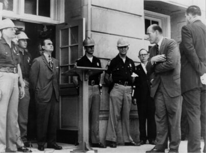
Today in History: June 11, University of Alabama desegregated
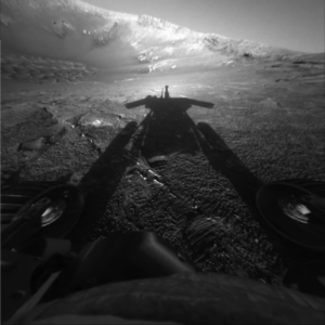
Today in History: June 10, Opportunity rover sends last message from Mars
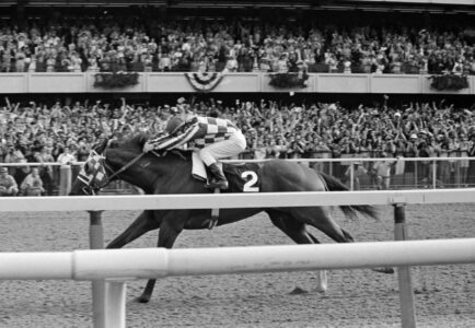
Today in History: June 9, Secretariat wins Triple Crown in record time

Today in History: June 8, Trump indicted on classified document charges