
Will it ever stop?
Snow, high winds predicted to make travel ‘impossible’ in some areas today; record for wettest February likely to be broken
Trending
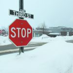
A stop sign peaks out of a snowbank along South Third Street in Marquette Saturday. Snowfall on Saturday preceded today's major winter storm, which is predicted to bring the highest wind speeds observed this season in the area, along with over a foot of snow in parts of Marquette County. Officials from the National Weather Service recommend staying off the roads if possible, as whiteout conditions could occur in some places today. (Journal photos by Cecilia Brown)
MARQUETTE -- A powerful winter storm is expected to dump heavy, wet snow and bring intense winds to Marquette County and the western half of the Upper Peninsula today, following a separate storm that brought snow to the area Saturday, according to the National Weather Service.
The storm that arrived Saturday was "just a precursor to what's to come later on," said Jordan Wendt, a meteorologist at the National Weather Service office in Negaunee, as forecasters expected to see a break in snow Saturday afternoon and evening before today's storm.
"Things will really start to ramp up around 1 a.m. (today) and the bulk of the snow that we're kind of expecting should fall between 1 a.m. and 7 a.m.," Wendt said. "There's a few spots in that timeframe that could pick up at least 10 inches or so, especially in the highlands in Marquette and Baraga counties."
As of Saturday evening, there is a winter storm warning in effect from 10 p.m. Saturday through 1 a.m. Monday.
The National Weather Service predicted snowfall rates could reach 2 to 3 inches per hour Saturday night through this morning across the northwest half of the Upper Peninsula, with snow accumulation expected to reach 12-18 inches in many parts of the northwest U.P. by this afternoon. Travel is expected to be "impossible in some areas west and north central" due to drifting snow and whiteout conditions today into tonight, according to the National Weather Service.
"Anywhere west of Marquette would be a solid 12 to 18 inches. Marquette itself is (expected to get) around a foot," Wendt said, noting 9 to 15 inches could fall in the Marquette area, with the city of Marquette likely to be on the lower end of snow totals.
In addition to the substantial snowfall, forecasters said the highest wind speeds so far this season are likely to occur with a low-pressure system moving in this morning, as gusts will start nearing the 30 mph range in the west around 8 or 9 this morning, and winds will develop in the east later as the low-pressure system moves through.
Wind gusts could reach 35 to 45 mph inland today and are likely to be even higher along the M-28 corridor east of Marquette.
"The maximum gusts are going to be expected a little after dinnertime but they'll gradually pick up through the day," Wendt said. "If you're east of Marquette near Lake Superior, it's not out of the question that you would see up to a 60-mph gust."
Even though the snow is expected to be heavy, the high wind speeds are likely to cause reduced visibility and whiteout conditions on the roads, especially in the west and north-central U.P., Wendt said, noting that high profile vehicles could be difficult to manage on some stretches of road with the wind.
"If it's not absolutely necessary to travel, I would recommend staying home," Wendt said. "These types of wind events don't happen too often up here, with the lake you can see some windier conditions, but we haven't had anything like this yet this year."
Wendt also cautioned the public about going near Lake Superior over the weekend, as winds, waves and shifting ice are likely to create a situation that is "quite dangerous," with ice pushing up on the shoreline and potentially causing flooding.
With today's storm occurring in an already wetter-than-average February, it's likely this February will become the wettest February on record for the area if predictions hold true, as only about a third of an inch of water equivalent was needed to break the 2002 record of 5.35 inches as of 1 p.m. Saturday.
While a substantial amount of snow is on the ground -- about four feet at the National Weather Service office in Negaunee -- it is unlikely this February will break the February record for snowfall, Wendt said. The record for the most snow in February was also set in 2002, with 91.9 inches, while this month's total was 70.7 inches as of 1 p.m. Saturday.
"There's an outside chance that we could break that, but we're not anticipating that," Wendt said.
For the updated information on the storm and current conditions, visit www.weather.gov/mqt/
Cecilia Brown can be reached at 906-228-2500, ext. 248. Her email address is cbrown@miningjournal.net.